Here you will find frequently used manuals for products available in our product range, including installation and activation guides. This page will be updated as new documents become available. Support is provided for software versions in accordance with the Octave and Hexagon Product Life Cycle and is limited to employees of your organization who are IMAGEM to IMAGEM .
Octave
Octave draws on decades of proven experience to solve customer challenges of any scale. From enhancing the resilience of critical services and infrastructure to enabling companies to design, build, and operate more profitable facilities. Our portfolio of solutions is broad, and our expertise is extensive. If you have a problem, Octave has the insights, the team, and the capabilities to help you tackle it. The list below highlights the key products for which documentation is available.
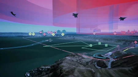
Octave Alto
Octave Alto, formerly known as Luciad, is intelligently designed for advanced visualization and real-time situational awareness. Check out the knowledge base on the Octave website.
Octave GeoMedia
Octave GeoMedia: a powerful GIS platform that enhances spatial data management. Gather information from multiple sources, perform dynamic analysis, and share insights with teams.
Octave Imagine
Imagine (formerly ERDAS ) delivers remote sensing . Turn imagery into insights. Move more quickly and with greater precision from complex geodata to confident decisions. Imagine is designed to meet the demands of modern professionals and combines advanced tools for image processing, analysis, and visualization into a single powerful platform.
Octave Alto Data Management
Formerly known as ERDAS , this enterprise data management and distribution platform provides an efficient way to organize, catalog, and share geographic and non-geographic data.
Octave Alto Lightspeed
The system formerly known as LuciadLightspeed provides rapid 2D/3D/4D geospatial insights and enables you to build mission- or domain-specific apps for use on the desktop and onboard.