Together with Hexagon Geospatial division, IMAGEM offers tools to visualize and analyze location data and gain insights to solve project- and business-related challenges. From desktop to browser to edge, bridging the gap between the geospatial and operational worlds.
Technology
Filter options
Use the buttons to filter the list of results. The list is updated automatically.
Select a filter to narrow down the results. The page will refresh automatically.
Digital Twin
IMAGEM
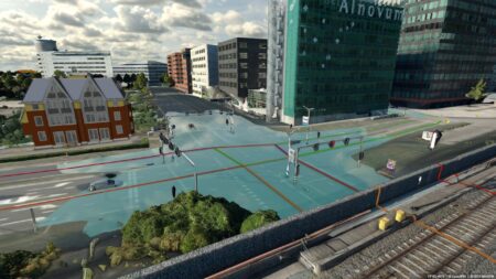
Planspace Simulator
As a municipality, you make decisions that have a major impact: from housing and infrastructure to climate adaptation and green space management. Every decision affects multiple areas. In housing, for example, factors such as the level of amenities, accessibility, and existing infrastructure play a key role. Issues related to the energy transition, climate adaptation, and circularity also influence one another. Often, there is no comprehensive overview of policy,...

IMAGEM
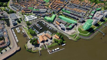
Oneport
Making available spatial data quickly and efficiently searchable and accessible—that’s what ONEPORT . Whether you’re setting up a central information hub internally or making data available to the outside world, ONEPORT ready to help. The combination of an intuitive search system, an ordering portal, and even the option to link this to an online payment service ensures that data can always be found and used quickly.
Hexagon
Power Portfolio
Power Portfolio of globally recognized and proven products that incorporate the best available technologies for GIS, remote sensing, photogrammetry, and data management. They help organizations collect, process, analyze, and understand geospatial data; organize geospatial and business data into centralized libraries for easy sharing; and deliver information via web and mobile applications—including custom apps and solutions.
More technologies
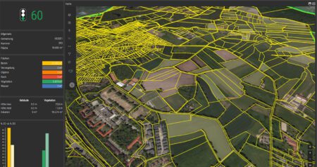
M.App X
The world around us is dynamic. Effective management information is too. M.App Enterprise provides a real-time view of your land area, allowing you to make dynamic selections and create orders. With M.App Enterprise, data-driven management becomes more transparent and intuitive than ever before.
ERDAS
ERDAS automatically searches for new data at designated locations within the system. Based on the metadata, ERDAS then makes the data available within and/or outside the organization, as an OGC-compliant web service and/or as a download. This allows you to quickly retrieve the latest reports or sketches for a project area.
Check M.App
Check M.App a web-based geospatial application that enables organizations to efficiently analyze and assess changes in the physical environment. The technology combines map data, external data sources, and process logic into a single digital workspace, allowing detections to be immediately visualized within their spatial context.
M.App Enterprise
The world around us is dynamic. Effective management information is too. M.App Enterprise provides a real-time view of your land area, allowing you to make dynamic selections and create orders. With M.App Enterprise, data-driven management becomes more transparent and intuitive than ever before.