IMAGEM a three-day training course designed to teach and demonstrate what it means to work with remote sensing , technology, and analysis. What remote sensing are available, where can I find them, when should I use which data to address my specific problem, and why? This training is intended for data scientists and GIS professionals who want to learn what Remote Sensing and how it can benefit their work.
What is remote sensing?
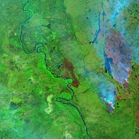
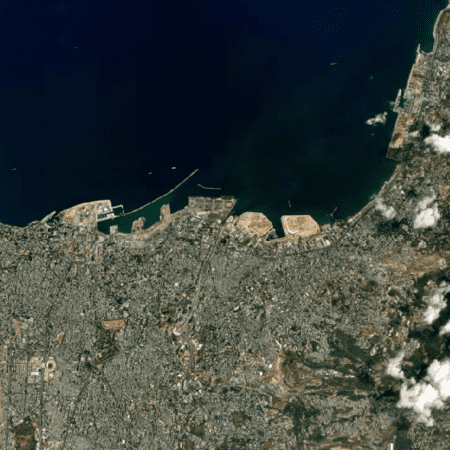
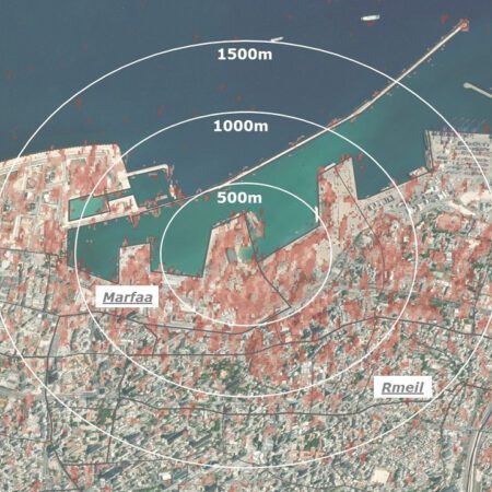
Remote sensing a technique used to gather information about an object or area without direct physical contact. This is done by collecting data from a satellite, aircraft, or drone. Various types of sensors are used, such as optical, radar, and infrared sensors. This data can then be processed and analyzed to support decision-making.
Combining remote sensing with data-driven decision-making offers significant benefits to municipalities, water authorities, and provinces in various areas such as urban planning, environmental management, and permitting, monitoring, and enforcement.
By utilizing remote sensing , policymakers and managers can make more informed and effective decisions. For example, using remote sensing can save time and money by allowing you to deploy personnel more efficiently in the field. You can implement measures in locations where they will have the greatest impact, such as identifying heat islands and implementing corresponding cooling measures.
Remote sensing also Remote sensing it easy to identify and monitor changes in hard-to-reach areas. Examples include green spaces and backyards, parks, plots of land, rooftops, and so on.
Topics covered
1. Data collection via remote sensing
Sensors and Platforms: Satellites, drones, and aircraft equipped with optical, radar, and infrared sensors collect data on specific areas.
Multispectral Imaging: The capture of data across multiple spectral bands to analyze various aspects of the landscape, such as vegetation, soil moisture, and urban structure.
2. Data Integration and Processing
Data fusion: The integration of remote sensing with other datasets, such as geographic information systems (GIS), weather data, and socioeconomic data.
Geospatial Analysis: The use of advanced software and algorithms to identify patterns and trends in the collected data.
3. Analysis and Interpretation
Machine Learning and AI: The use of machine learning and artificial intelligence to gain insights from large amounts of data, such as predicting crop yields or detecting deforestation.
Visualization: Creating maps, charts, and other visualizations to make complex data understandable for decision-makers.
4. Data-Driven Decision Making
Scenario Analysis: Simulating various scenarios and their impact based on the analyzed data. For example, assessing the impact of climate change on water resources.
Optimization: Identifying the most efficient and effective measures based on detailed and up-to-date data. For example, optimizing irrigation in agriculture to reduce water consumption.
Monitoring and Evaluation: Continuously monitoring the effects of decisions made and making adjustments based on new data. For example, tracking urban expansion and revising land-use plans.
This training course is divided into three days:
Day 1
-
We’ll start the day with a relaxed get-together, where you’ll have the chance to grab a cup of coffee and meet the other participants. This is a great opportunity to prepare for the informative day ahead and to network with like-minded professionals.
-
The course day begins with a brief introduction during which we’ll go over the day’s schedule and introduce you to the other participants. This will give you a clear idea of what to expect and help you understand how the different sessions complement each other.
-
In this session, we’ll dive into the world of remote sensing. We’ll discuss remote sensing what remote sensing entails, the different types of sensors available, and how this technology is applied. This foundational knowledge is essential for moving on to the more advanced applications later in the day.
-
Take a short break to recharge and discuss what you’ve learned so far with your classmates. Use this time to think of any questions you’d like to ask during the upcoming sessions.
-
In this session, we’ll explore where valuable data comes from in the Netherlands and what we can do with it. We’ll dive into the satellite data portal, the AHN, and imagery. You’ll have the opportunity to view and analyze data yourself using the remote sensing Erdas . This hands-on portion will help you see firsthand how the theory works in practice.
-
Enjoy a well-deserved lunch break, fully provided by IMAGEM, where you can relax and catch up with your fellow students. This is a great opportunity to share experiences and gain new insights.
-
After lunch, we’ll continue exploring how to monitor changes using remote sensing. We’ll learn how to use indices and change detection. You’ll then get hands-on experience with simple index and change detection models, allowing you to see firsthand how these techniques work.
-
A short break to catch your breath and get ready for the last part of the day. This is also a good time to ask any questions you may have about the sessions you’ve attended.
-
In this session, we’ll focus on analyzing data using remote sensing. We’ll discuss applications such as detecting flooding with RADAR and identifying objects. You’ll have the opportunity to extract simple vegetation and building data from a point cloud yourself and color it in using aerial photographs. This hands-on component allows you to immediately apply the knowledge you’ve gained.
-
We’ll wrap up the day with a brief review and a summary of what we’ve learned. This is also the time to ask any final questions and exchange contact information with the trainers and your fellow participants. You’ll go home with new knowledge and skills that you can immediately apply in your work.
Day 2
-
On the second day of the training, we’ll start with another relaxed warm-up. This is a great opportunity to network, discuss your experiences from the first day, and prepare for the new topics we’ll be covering today.
-
The day begins with a brief introduction during which we go over today’s schedule and have another chance to get to know the other participants. This helps us start the day off right and get everyone on the same page.
-
In this session, we will explore how we can use remote sensing to detect remote sensing and drought. We will examine where it is hot and where vegetation is struggling. This knowledge is crucial for understanding environmental issues and planning appropriate measures.
-
A short break to recharge and process the information from the first session. This is also a good time to think of any questions you might have for the next session.
-
We’ll delve into change detection, learning where changes have occurred. You’ll have the opportunity to perform your own analyses using advanced tools and discover how changes in the landscape can be identified and analyzed.
-
Enjoy a well-deserved lunch break, fully provided by IMAGEM, where you can relax and share experiences with your fellow students. This is a great time to reflect on what you’ve learned and prepare for the afternoon.
-
After lunch, we’ll focus on advanced vegetation monitoring. We’ll compare vegetation cover between two years and identify areas where conditions are favorable, where improvements are possible, and where vegetation is declining. This hands-on session will give you insight into how to track trends and changes in vegetation.
-
Take a short break to catch your breath and prepare for the last session of the day. Use this time to gather your thoughts and formulate any questions you may have.
-
In this session, we’ll delve deeper into the subject matter and explore advanced change detection, combining various sensors to detect changes in the landscape with even greater accuracy. You’ll learn how to use these advanced techniques to gain valuable insights for a variety of applications.
-
We’ll wrap up the day with a brief review and a summary of the topics covered. This is also the perfect time to ask any final questions and exchange contact information with the trainers and your fellow participants. You’ll leave with in-depth knowledge and practical skills that you can immediately apply in your work.
Day 3
-
We’ll start the third day of the training with another relaxed check-in. This gives you a chance to ease into the day, have a cup of coffee, and catch up with your fellow participants about the informative days behind you.
-
This final day begins with a brief introduction in which we go over today’s agenda. This helps us get the day off to a good start and ensures everyone is on the same page regarding the topics we’ll be covering.
-
In this session, we’ll take a closer look at LIDAR technology. We’ll discuss what LIDAR data is, how you can use it, and how to create a point cloud. This is an essential foundation for conducting further analyses and applications using LIDAR data.
-
A short break to recharge and process the information from the first session. This is also a good time to think of any questions you might have for the next session.
-
In this session, you will learn how to perform basic analyses using LIDAR data. We will cover the creation of digital elevation models (DEM/DTM) and profile analyses. This hands-on session will give you the opportunity to work directly with the data and gain practical experience.
-
Enjoy a well-deserved lunch break, fully provided by IMAGEM, where you can relax and share experiences with your fellow students. This is a great time to reflect on what you’ve learned and prepare for the afternoon.
-
After lunch, we’ll continue exploring how to use LIDAR data to identify, classify, and model objects such as buildings and vegetation. You’ll learn how to apply LIDAR data to perform detailed analyses and gain valuable insights for a variety of applications.
-
Take a short break to catch your breath and prepare for the last session of the day. Use this time to gather your thoughts and formulate any questions you may have.
-
In this session, we’ll combine LIDAR datasets with supplementary data to perform more in-depth analyses. You’ll learn techniques for underwater and above-water analyses and volume calculations. These advanced applications will help you gain even deeper insights and solve complex problems.
-
We’ll wrap up the day and the training with a summary of the topics covered and a brief evaluation. This is also the time to receive your certificate and ask any final questions. You’ll go home with in-depth knowledge and practical skills that you can immediately apply in your work, and you’ll be ready to put your new skills into practice.
The cost depends on the training program you choose. We would be happy to discuss your needs with you to create a personalized training program tailored to your preferences.
Who is this training intended for?
For anyone interested in working with remote sensing.
Location
At your location.
Find out about the options
IMAGEM a digital twin in the cloud for you. With our support, you can then create data yourself, configure 3D viewers, and experiment with data server and web viewer environments via the web. We provide you with the insights and tools you need to set up your 3D environment efficiently and practically.
This training course will help you build a solid foundation for working successfully with 3D environments and take your expertise to the next level! Request more information and grow alongside the future of digital twins.