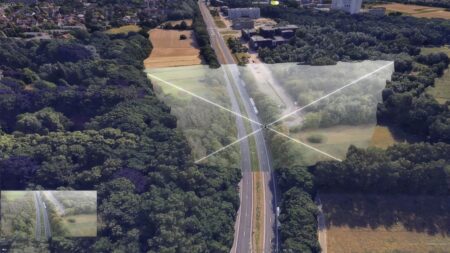
Drone data processing is the conversion of raw data from drone sensors into information that you can view and analyze. Examples include aerial photos, thermal images, and LiDAR data that are processed into orthophotos, point clouds, terrain models, or realistic 3D environments. These information products provide a detailed picture of reality. For example, you can use them to assess distances and elevations, inspect objects, and analyze changes in an area.
The information products you need depend on the question you want to answer. Sometimes a current aerial photo is sufficient, while for other applications you may need a detailed 3D model or have to combine data from various sources. The way you plan to use the information also plays an important role. That’s why IMAGEM doesn’t start with the drone or the processing technology, but with your information needs.
From information needs to decision-making: a single, integrated information chain
To make the right information available, data collection, processing, analysis, and integration must be well-coordinated. IMAGEM brings these components together into a single information chain. We determine what data and technologies are needed, how we can enrich the data, and how the results will be made available in the systems you use. In this way, we work through six steps—from an information request to information you can use to support your decisions.

Information Needs
We identify which questions you want to answer and what information is needed to do so. In doing so, we consider timeliness, level of detail, accuracy, and the intended use.

Data Collection
We determine which data sources, platforms, and sensors are suitable. This could be a drone, but it could also be another sensor or an existing information source.

Data Processing
We convert raw sensor data into information products such as orthophotos, point clouds, terrain models, and 3D models.

Analysis and Enrichment
We combine the processed data with other geographic information and data sources. This allows you, for example, to analyze objects, changes, and spatial relationships within their context.

Accessibility and Integration
We integrate the information into the applications, systems, and workflows that users work with. This ensures that the data is not limited to individual files or separate software environments.

Information and Decision-Making
Users have access to up-to-date, relevant information to assess situations, conduct analyses, and support their decisions.
Skyline PhotoMesh: From Sensor Data to 2D and 3D Geodata
An important part of the information chain is the processing of raw sensor data into accurate spatial information. Especially when dealing with large volumes of drone imagery, aerial photographs, and other sensor data, this requires technology that not only delivers detailed results but can also be deployed in a scalable and efficient manner.
That is why IMAGEM is collaborating with Skyline, the developer of Skyline PhotoMesh, among other products. Through our strategic partnership, we combine Skyline’s 3D technology with our expertise in geoinformation, data analysis, and system integration. This enables us to support organizations in the end-to-end processing, management, and use of 2D and 3D geodata.
What makes Skyline PhotoMesh valuable?
PhotoMesh uses photogrammetry to process large volumes of imagery into detailed 3D models and other spatial information products. The technology supports scalable processing and automation, enabling even large datasets to be processed efficiently.
What data and information products does PhotoMesh support?
PhotoMesh supports various types of input data, including drone imagery, aerial photographs, video, LiDAR data, and multispectral imagery, such as near-infrared (NIR). Depending on the available data and the application, these can be used to create various information products:
- 3D meshes: realistic, detailed 3D models of areas, buildings, and infrastructure.
- Orthophotos and true orthophotos: geometrically corrected aerial images for accurate spatial representation and analysis.
- Point clouds: 3D collections of points that can be used to capture the geometry of objects and environments.
- Digital Surface Models (DSM): elevation models that include buildings, trees, and other objects.
- Digital Terrain Models (DTM): elevation models of the terrain without above-ground objects.
- Digital twin models: detailed digital representations of physical environments that can serve as a spatial basis for further analysis.
PhotoMesh also supports scalable processing of large datasets. Through automation and API integrations, processing workflows can be integrated into broader data workflows, depending on the chosen solution.
From 3D Processing to Centralized Management and Use
A detailed 3D model is valuable, but it must also be accessible to the people who work with it. That is why we look beyond processing alone. In addition to PhotoMesh, Skyline offers technology for managing, visualizing, and distributing spatial information. With SkylineGlobe Server, large 2D and 3D datasets can be centrally managed and made available to various users and systems. TerraExplorer offers capabilities for interactively viewing and analyzing this information in a 3D environment.
IMAGEM integrates these technologies with other geoinformation, GIS applications, and existing IT systems as needed. Additional analytical techniques, such as AI-driven object recognition and change detection, can also be used to extract relevant information from the data. This not only creates a realistic representation of reality but also an integrated information environment that supports organizations in monitoring, inspection, asset management, safety, and decision-making.
IMAGEM and Skyline: A Strategic Partnership
IMAGEM and Skyline are collaborating to support organizations in the Benelux region in processing, managing, and applying 3D geodata. Skyline provides the specialized technology and international expertise. IMAGEM handles the translation into concrete applications, as well as the implementation and integration into existing systems and workflows. Through this partnership, we can guide organizations from their initial information request to a scalable solution for the daily use of spatial information.
Drone Data for Safety, Monitoring, and Asset Management
Information needs vary by organization and application. One recurring need is for up-to-date, reliable spatial information that aligns with the work process.
- Safety and situational awareness: What does a location look like right now, and what information is needed to properly assess a situation? With real-time drone imagery and 3D environments, you can analyze locations, identify objects, and estimate distances or heights. Combining this information with other geospatial data enhances situational awareness, for example, when preparing for operations or analyzing changing situations.
- Monitoring and Land Management: What has changed in an area, and where does this require attention? By recording and comparing up-to-date spatial data, you can analyze changes in the environment. This supports the monitoring of areas, land management, and tracking developments related to projects.
- Inspection and Asset Management: What is the current condition of infrastructure or other assets, and what information is needed for management? Drone data and other sensor data provide detailed spatial information for inspections. By processing, analyzing, and combining the results with other information sources, they can be integrated into existing management and asset management processes.
IMAGEM: the link between data, technology, and the user
There is no single sensor, dataset, or software package that can answer every information request. Sometimes you need up-to-date drone imagery; other times, you need satellite data, LiDAR measurements, existing maps, or information from other systems. Often, the greatest added value comes precisely from combining different sources and technologies.
IMAGEM specializes in bringing these components together. As a systems integrator, we connect drone and sensor suppliers with technology for data processing, GIS, 3D visualization, analysis, and—where relevant—AI. In doing so, we consider not only the technology itself, but also the existing IT and geo-architecture, the workflows, and the people who ultimately use the information.
Our expertise lies in translating an information need into a cohesive solution. What data is already available? What additional measurements are needed? How do we process and analyze the data? And how do we ensure that the results are made available in the applications users work with? We are not limited to a single sensor, platform, or technology. We bring the right building blocks together and ensure they work seamlessly with one another. After all, the goal is not to collect as much data as possible, but to make information available that allows you to assess situations and support your decisions.
What does your organization hope to gain from drone data?
Would you like to process drone imagery into a realistic 3D environment using Skyline PhotoMesh? Do you already have sensor data, but want to combine it with other sources of information? Or are you looking for a way to integrate up-to-date spatial information into your existing systems?
IMAGEM helps you determine the right approach and technology—from your initial inquiry to an integrated solution for analysis, monitoring, and decision-making. Please contact Harald or send us a message via our contact form.