
Fast and reliable information makes all the difference when it counts. Yet in practice, drone data often remains scattered across individual images, separate software steps, and fragmented workflows. IMAGEM and Skyline are changing that. Through an equal partnership, we combine data collection, 3D processing, centralized data management, and visualization into a single integrated chain. The result: immediately actionable 3D insights that help organizations understand faster, make better decisions, and act more effectively.
The growth of drone data calls for a mature and scalable approach
Drone technology is advancing at a rapid pace and is playing an increasingly important role in security, asset management, infrastructure, and land development. Organizations are collecting more and more imagery, but often get stuck in the process of transforming raw data into usable and versatile information. Fragmented tools, limited processing capabilities, and weak links in the chain slow down the process and increase the risk of errors.
That is precisely why there is a growing need for a solution that goes beyond mere data processing. Organizations are looking for an integrated approach in which data is not only collected but can also be centrally managed, securely shared, and practically applied in day-to-day operations. IMAGEM and Skyline are meeting this need.


A strategic partnership that brings the entire supply chain together
The collaboration between IMAGEM and Skyline is structured as a substantive partnership, not a traditional reseller model. Both parties complement each other through their expertise, market knowledge, and a shared vision regarding the use of 3D geodata in operational and administrative processes.
Skyline brings technology and international expertise in the fields of 3D reconstruction, geospatial streaming, centralized data management, and visualization. IMAGEM translates this technology into practical applications within the Benelux region and ensures its integration into real-world applications in the areas of security, asset management, government, and commercial projects.
This partnership makes it possible to provide customers not only with technology, but with a comprehensive and future-proof workflow: from data capture to actionable insights.
The field of security is evolving at breakneck speed. That is precisely why I firmly believe that sustainable partnerships are indispensable. Only through close collaboration can technology truly contribute to better insight, faster action, and greater control in complex situations.
— Eric-Jan van Alten, CEO of IMAGEM
Skyline: From 3D Reconstruction to Centralized Management and Distribution
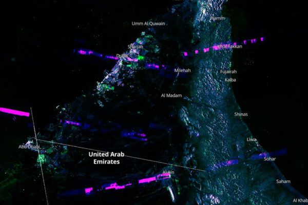
Within this partnership, PhotoMesh plays a key role in processing drone imagery, aerial photographs, and other data sources into accurate 3D models, meshes, and orthophotos. This creates a reliable digital representation of reality that serves as the basis for further analysis, inspection, and decision-making.
In addition, developments related to Gaussian Splats are also relevant. This technology enables high-quality, photorealistic 3D visualization and excels in visual quality, detail rendering, and realism. This makes Gaussian Splats particularly interesting for applications where not only accuracy is important, but also a quick and convincing visual interpretation of a location, object, or environment.
Equally important is what happens to that data after processing. With SkylineGlobe Server, Skyline offers a powerful platform for centrally managing, streaming, and securely making large 2D and 3D geodata sets available within organizations. This allows multiple users and teams to work with the same up-to-date and consistent information, without relying on individual files or fragmented storage. For interactive consultation and practical use, TerraExplorer can also be used as an accessible 3D viewer.

From drone flight to immediately usable 3D insights
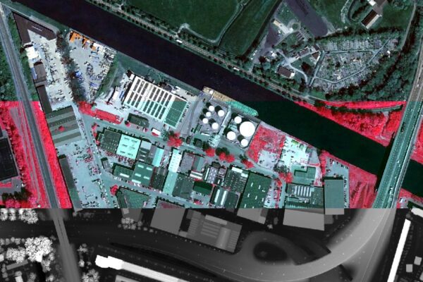
The strength of this collaboration lies in speed and consistency. A drone captures imagery of an object, area, or infrastructure, after which this data is processed into an accurate 3D model or high-quality visualization. The output is then centrally managed and made available to the people who need to work with it.
This provides immediate added value in situations where time, situational awareness, and reliability are crucial. Consider emergency services that need a quick overview of a building or incident site. But also consider municipalities and facility managers who want to accurately map infrastructure, critical facilities, or urban areas and make this data widely available for inspection, planning, and maintenance.
Widely applicable in security, government, and management
The combined solution from IMAGEM and Skyline can be used in a wide range of fields where reliable geospatial information is essential. Examples include:
- 3D mapping of buildings, sites, and critical infrastructure
- Incident preparedness and operational scenario analysis
- Inspection and management of bridges, viaducts, and infrastructure
- digital twins for urban development and spatial issues
- centralized distribution of up-to-date 2D and 3D data across teams and organizations
- Secure access to geoinformation for multiple users and locations
This results not only in a technical model, but also in a scalable information system that can be put to immediate practical use.

Why this partnership is important to Skyline
For Rutger van Kan, Technical Director Europe at Skyline, this partnership is a logical and valuable step. For Skyline, it is important to maintain close ties with the region. With IMAGEM, we have a partner that not only understands our technology well but can also translate it into concrete, practical applications. This allows us to support customers in the Benelux more closely and more quickly, with a dedicated team in the region and stronger first-line support. This is not only valuable for our customers but also forms a strong foundation for further joint growth.
What makes this partnership so strong is that we complement each other both in terms of expertise and commercially. We operate in many of the same markets and therefore have a deep understanding of what customers need. This includes sectors such as defense, emergency management agencies, local governments, and the commercial market, where speed, reliability, and practical applicability are of the utmost importance.
— Rutger van Kan, Technical Director Europe at Skyline
Short lines of communication, regional influence, and better support
A key benefit of this partnership is the combination of technological expertise and regional proximity. For customers in the Benelux, this means short lines of communication, a dedicated team in the region, and a better alignment with local needs and industries.
The partnership between IMAGEM and Skyline will result in stronger first-line support for customers in the Benelux. Issues can be addressed more quickly, use cases can be better understood, and projects can be managed more effectively. This not only improves the quality of service but also boosts adoption rates and the practical benefits of the solutions.
A single integrated supply chain as the foundation for speed and decision-making
IMAGEM and Skyline’s ambition goes beyond technology alone. Their goal is to support organizations with a comprehensive, scalable, and future-proof 3D workflow in which all components fit together seamlessly.
By integrating data collection, processing, centralized management, visualization, and distribution, a workflow is created that is less reliant on standalone tools and manual transfers. This reduces the time between data capture and actionable insights, increases the reliability of the output, and makes 3D data structurally applicable in daily practice.
How IMAGEM helps
IMAGEM combines technology, data, and domain expertise to create practical solutions. In this partnership, IMAGEM takes the lead across the entire process: from drone data to actionable 3D insights. The focus is not on the technology itself, but on how organizations can gain insights more quickly, collaborate more effectively, and better prioritize safety, management, and execution.
About Skyline
Skyline is an international software provider specializing in 3D geospatial technology. The company develops solutions for processing, managing, streaming, and visualizing large amounts of geospatial data in a realistic 3D context. With products such as PhotoMesh, SkylineGlobe Server, and TerraExplorer, Skyline helps organizations transform complex data into actionable insights for operational, tactical, and strategic applications.
More information
Eric-Jan van Alten is the CEO of IMAGEM. With a background in accounting and years of experience in the software industry, he helps organizations leverage technology effectively to improve efficiency and ensure future-proofing. He combines expertise in sales, strategy, marketing, and digital transformation, always keeping the organization’s impact in mind. For clients, this means pragmatic solutions that really work. Want to learn more? Send Eric-Jan an email or send a message via our contact form.