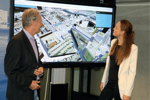

A single environment where the physical, legal, and administrative realities converge in a policy-aware digital twin. Ever seen anything like it? Over the past two years, IMAGEM Apeldoorn, has Planspace and presented it at GeoBuzz as a “lifeline for the Environment Act.” Niels van de Graaf, government market manager at IMAGEM why a municipality can benefit so much from using Planspace.
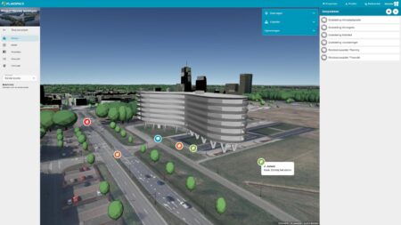
Planspace a virtual collaboration environment for integrated stakeholder analysis, which helps us improve decision-making and shorten the decision-making process. But what exactly is it? Niels van de Graaf explains: “Three things Planspace together in Planspace . It is a digital copy of the physical living environment in which information and data on topics such as housing, heritage, mobility, the economy, retail, ecology, green spaces, culture, water, social issues, and other subjects are made transparent. Most people are familiar with this as a ‘digital twin.”
But Planspace much more than that. In addition to a “standard” digital twin, IMAGEM creates a digital twin policy that incorporates the ambitions and objectives of each domain. This leads to greater engagement and better collaboration. That Planspace unique collaborative environment where all stakeholders can work together to develop “what-if” scenarios and collaboratively arrive at smart solutions.
Digital twin .0
Let’s go back to basics: the digital twin. Digital twins true game-changers in urban development. “In a digital twin , the physical environment digital twin digitized, allowing you to bring the outside world inside. The biggest advantage is that this gives all stakeholders the same perspective on the situation,” explains Niels.
“This allows decision-makers to ‘visualize’ the living environment and various scenarios. Different scenarios can be tested, enabling informed decision-making. In addition to a digital twin the physical living environment, we are now also creating a digital twin the visions, strategies, and policies for, say, a municipality. We digitize municipal policy documents containing ambitions, objectives, opportunities, risks, and impacts, and these are represented as a goal tree in Planspace promote coherence in policies for the living environment as well as the implementation, monitoring, and evaluation of those policies.”

Planspace with:
- Bringing stakeholders together to tackle challenging tasks
- Depicting the desired physical environment through 3D visualizations and simulating the effects of interventions by analyzing the consequences of different alternatives
- Empowering stakeholders to develop widely supported alternatives that contribute to addressing societal challenges
- Cross-domain collaboration
- Faster and more informed decision-making
- Reducing failure costs through scenario planning

Planspace: for both the government and citizens
Dutch municipalities are currently facing major, complex challenges such as the energy transition, housing construction, and climate change. New insights are needed to address these issues in a comprehensive manner. Municipalities are seeking solutions to visualize the various interconnected urban developments over the coming years. These include the effects on mobility flows, parking, employment, climate, housing construction, and the energy transition. Niels: “We’ve noticed that policy staff want to engage not only a city’s administration but also its citizens in relevant development scenarios using recognizable and interactive visualizations.”
Come along
A digital twin a tool for communication and scenario creation, supports policy-making and simplifies information sharing. Both simple and complex projects digital twin be visualized in a digital twin . Stakeholders involved in the planning process immediately gain a clear picture of the situation or scenarios. Policies regarding parking, green spaces, and mobility, for example, can be explicitly outlined, thereby immediately highlighting any contradictions.
Niels: “So you can immediately see where policies conflict and start a dialogue. Of course, it helps enormously when a municipality is open and transparent, showing what the plans are, what the consequences are, and what it intends to do about them. In addition to enabling the city council to make a well-considered decision based on the clarity and context of the scenarios, Planspace can Planspace be taken ‘under the arm’ to citizens and business owners to explain plans and discuss them transparently. There is no longer a gap in perception, and citizens can align their world with that of the government.”
Planspace easy to share with all stakeholders throughout the entire process. A single, integrated information system with a single source of truth ensures that everyone has access to the same information across the various phases, leading to better decision-making.
With Planspace , you Planspace visualize and comprehensively assess plans during the informal phase—the preliminary consultation. This is the key to speeding up the process. Just imagine what it would mean to have insight into the feasibility of a construction plan at this stage. And, above all, what this will mean for the procedural phase.
— Niels van de Graaf, Government Market Manager at IMAGEM
A lifeline for the Environment Act
Planspace not only an intelligent collaboration environment designed, for example, to assess the feasibility of visions and strategies or to support preliminary discussions for a construction project. It is also capable of assisting knowledge workers with integrated decision-making under the Environment Act. “We all know that the complexity is high and that this complicates decision-making. What would it mean if you could simplify this complexity? And how do you provide the best service to non-governmental parties such as construction professionals, architects, urban planners, and private individuals? A purely technical or purely legal approach is not the solution. But when you combine these very intelligently, it helps enormously,” says Niels.
Planspace decision-making under the Environment Act by intelligently linking a wide variety of sources—such as basic registries, local regulations, formal regulatory frameworks, and case law—and, above all, by applying them effectively. It also makes complex analyses and assessment requirements for the built environment accessible to every project developer and municipal official. Under the hood, Planspace applies Planspace legal and technical domain knowledge to a scenario that the project initiator simply fills out.

Planspace answer important questions such as:
- Is it technically feasible to build X homes of these types?
- Is it safe to live there, given the sensitive activities taking place in the surrounding area?
- Is there a nearby water protection area?
- What is the planning area as defined by the zoning plans?
- Do specific zoning regulations play a role?
These are all questions aimed at determining whether the plan is feasible for the initiator, but also whether the impact on those directly and indirectly affected is acceptable. To answer these questions, various sources are used and combined in Planspace gather facts and supporting evidence: Rijkswaterstaat, water boards, municipalities, DSO, RVO, the Land Registry, and so on. Facts are combined, classified, and analyzed using explicit domain knowledge.
The key to acceleration
With Planspace , you Planspace visualize and comprehensively assess plans during the informal phase—the preliminary consultation. This is the key to speeding up the process. Just imagine what it would mean to have insight into the feasibility of a construction plan at this stage. And, above all, what this will mean for the procedural phase.
More information
Niels is the Government Market Manager at IMAGEM. He helps government agencies continuously work smarter and more effectively, and fulfills his role by supporting organizations in solving their challenges. Want to learn more? Send Niels an email or send a message via our contact form.

Niels van de Graaf
Government Market Manager