
You sometimes see them driving around town—those cars with a menacing array of cameras on the roof. Like hungry wolves, they efficiently cruise through the city in search of license plates that aren’t currently registered in the parking meters, or whose registration has expired. The chance of getting caught these days is many times greater than it was back when parking enforcement officers patrolled the streets. And then there were those yellow tickets under your windshield wiper.
Just think of how many more parking violators can be caught these days with far fewer parking enforcement officers! As an occasional parking violator, I think: unfortunately… As an IT specialist, I think: it’s great that things work so efficiently these days! And it’s strange that modern technologies like image analysis aren’t being used in government enforcement efforts
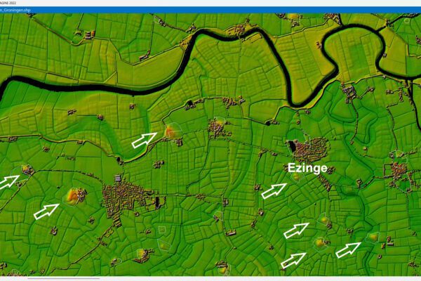
Enforcement in rural areas
These modern techniques can be used not only by government agencies but also by other managers in rural areas. To assess the status or condition of, for example, a road, waterway, dike, etc. The benefits of using remote sensing are even greater in these cases. Consider the thousands of kilometers of roads, waterways, and dike sections, as well as broken streetlights and illegal or unpermitted structures.
Just imagine the savings you could achieve by using satellite imagery, aerial photography, or even LiDAR (laser scanning) to capture a large area, providing a high-quality assessment of the condition of a road, waterway, or flood barrier. Then have that data analyzed by smart algorithms. Then present an image that clearly shows the enforcement officer where there is a high probability that the condition is ‘good’ and where it is ‘not good.’ As an enforcement officer, wouldn’t you then only go to the places where there is a high probability that the condition is not good?
Just like a parking enforcement officer, the inspector doesn’t have to assess every waterway personally; instead, you leave the assessment to a smart algorithm. You only enforce regulations at locations where conditions are ‘unsatisfactory’ or where a clear assessment cannot be made. This results in significant savings in personnel costs. This is an absolute necessity, as the availability of skilled personnel is already declining due to an aging workforce.
Enrich
And yes, digital assessments are already being conducted in outdoor settings for enforcement purposes. However, the practical application of remote sensing areas such as Dutch water management remains limited (source: Exploration of Remote sensing for Water Management, Stowa).
All too often, there is still some hesitation about relying on it. The idea is that there are certainly advantages to not having to assess every location in the field. But we also want to form our own opinion. Because relying solely on the digital assessment is often a step too far. So how can you use the preselection phase of the digital assessment process to quickly and efficiently enrich the digital assessment to the point where the enforcement officer or inspector has sufficient confidence in the final assessment to not visit the location?
Automating manual reviews
This question reminded me of a conversation I had some time ago with a university professor. We discussed the grading workload involved in evaluating large numbers of open-ended exams. He explained that, especially during and after the COVID-19 pandemic, answers to (open-ended) exam questions are almost always entered via computer and are therefore available digitally. When grading, the grader then checks off the elements that the given answer must contain in order to be (partially) approved. The count of correct elements in the answer is tracked automatically. The application then moves on to the next assessment. The number of actions required during grading is usually limited to simple mouse clicks. This has drastically reduced the grading workload and turnaround time.
Screen inspection or visual inspection
With that in mind, we have sought to achieve the same level of efficiency. For example, when assessing a digital assessment in a satellite image regarding encroachment into a waterway, damage to the grass surface (dike section), or illegal construction. In other words, we do not review every single assessment, but only those that pose a risk in relation to the enforcement objective (in this case, proper water drainage).
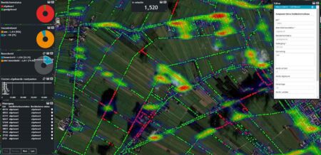
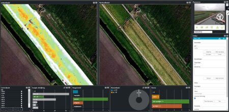
Monitor Inspection
How does this work? An inspector is presented with a map in a web browser showing locations where a digital assessment has been made. The assessment must be validated (e.g., borderline case or high-risk area). These filters can be configured using widgets.
Just as with the correction app used at an educational institution, the inspector can automatically zoom in on the reported violation based on the recording. Where applicable, a panoramic photo of the surroundings can also be displayed simultaneously to facilitate a more accurate assessment. With just one click, the employee can change a ruling or initiate a physical follow-up.
The system automatically zooms in on the next violation. This allows hundreds to thousands of digital assessments to be reviewed in a short period of time, either systematically or based on risk. And that takes only a fraction of the time required for a physical inspection of all waterways or structures.
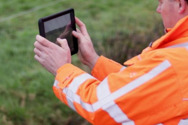
If an inspector is unable to reach a conclusion digitally at a site, they will use a mobile app. In this case, the inspector can make a final assessment directly at the site. However, the number of field visits is much lower than it would be if they did not have the app.
Tools to facilitate risk-based enforcement
It’s hard to imagine today that a parking enforcement officer would issue a ticket for every violation, or that a teacher would jot down grades in the margins with a pen. Now is the time when enforcement officers in rural areas, too, can perform their duties in a much more targeted and efficient manner thanks to smart assessment algorithms and user-friendly apps. A hybrid assessment process (digital and visual checks) serves as a tool for the enforcement officer, enabling them to carry out their enforcement duties in a risk-based, more targeted, and efficient manner.
And thus, enforcement is limited to where it is necessary.
More information
Tjip is a business consultant at IMAGEM. As a consultant, he helps organizations—such as water authorities—find answers and solutions to spatial challenges, where the key lies in the smart application of location intelligence. Want to learn more? Send Tjip an email or message us via our contact form.

Tjip van Dale
Business Consultant