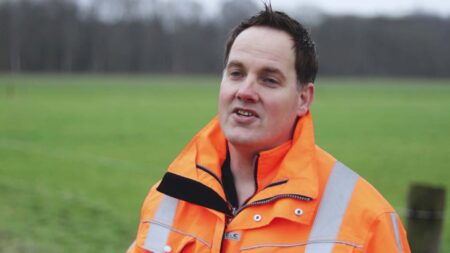
For years, the process has been exactly the same. In the fall, more than 60 employees of the Drents Overijsselse Delta Water Board (WDODelta) head out into the field to check ditches for proper flow. Specifically, this involves ditches for which landowners whose property borders a ditch are responsible for maintenance—the inspection ditches. This process is called the inspection. Now, thanks to satellite inspection, that same inspection looks very different. Erik Pander, a supervision and enforcement officer at WDODelta, shows us how.

The culvert is important for ensuring proper water flow in ditches. Good flow is important and ensures that any excess water in an area can be quickly drained away. This prevents fields and farmland from becoming too wet. That way, no one gets wet feet. Overgrowth or other debris in a ditch can block the flow of water. Think, for example, of aquatic plants, reeds, branches, and leaves. In such cases, the water authority sends the landowner responsible for maintenance a warning to clean the ditch by a certain date. If the landowner fails to do so, they risk a fine.
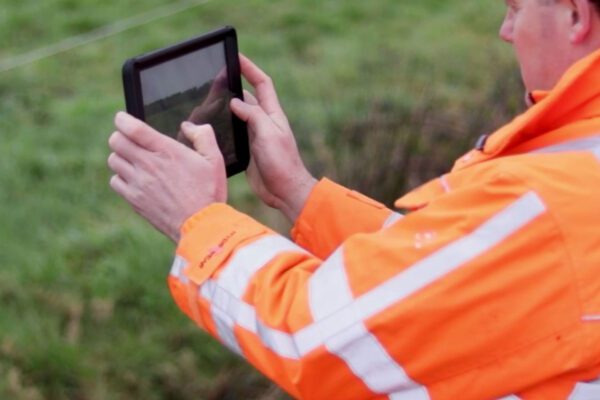
This is one of the tasks carried out by the water board’s enforcement officers, including Erik Pander. In the past, the water board relied on a large number of people in the field to conduct inspections. Now, Erik and his colleagues can do some of this work from their desks and only go out into the field when necessary—using a tablet as part of the Schouw M.App solution. This way of working has drastically changed the inspection process.
I would definitely recommend that other water authorities also explore the possibilities of digitizing a process such as the inspection
— Erik Pander, Supervision and Enforcement Officer at the Drents Overijsselse Delta Water Board
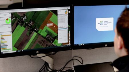
Digital inspection
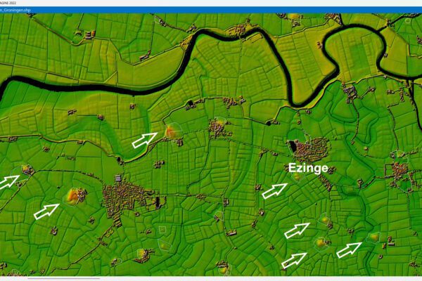
The updated inspection process begins with a digital or satellite inspection. Satellite images of the water board’s area are analyzed using artificial intelligence. A smart algorithm is used to check whether ditches that play a role in drainage have been “properly” or “improperly” cleaned. In this way, ditches are approved or rejected. On the screen, the status of a waterway is visualized using the colors red and green. This information is used to visually assess the number of rejected waterways. Using the satellite image and local knowledge, the inspector can designate the waterway as “clean” and “overrule” the satellite inspection’s assessment.
Monitor inspection from your desk chair
Enforcement officers use the “Beeldschermschouw” app for this purpose. The number of watercourses that remain unapproved after this process is verified during the field inspection, and enforcement officers then go out into the field. The advantage is that only watercourses classified with a high degree of certainty as “not clean” by the enforcement officer are physically inspected. Waterways for which the satellite inspection is notoriously unreliable (under trees and in built-up areas) are also physically inspected. As a result, the number of field inspections has already been significantly reduced.
Inspection of rejected waterways
Enforcement officers now know which areas still need to be inspected. At this stage of the process, they conduct on-site inspections to verify whether the waterway has been cleaned. Only the landowners whose ditches were found to be non-compliant during the field inspection receive a letter. The Schouw M.App thus saves a significant amount of time and resources. It ensures that inspections are carried out more efficiently and reliably.
Erik has really noticed that change: “Back in the day, it took 60 of us two weeks to inspect all the ditches. It was just second nature to walk through the fields with your colleagues. When you suddenly have to rely on an aerial photo, that does require some adjustment on people’s part.” Fortunately, Erik and his colleagues quickly realized the benefits of the solution. “Now we can filter out all the cleaned ditches from our desks and focus on the ones that haven’t been maintained yet. That saves us a lot of time and effort. And, of course, money too.”
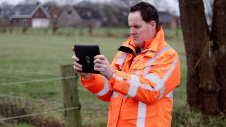
On the go with your tablet and Schouw M.App
Erik notes that Schouw M.App already achieves a high level of accuracy in detecting unmaintained ditches. “The accuracy of the satellite inspection depends on many factors, such as the quality of the image and the layout of the area. If there are a lot of trees, you can’t see a ditch clearly, but in an open field, the solution is very accurate. Across the entire area, we can already rule out over 75% of the ditches for inspection using the screen-based inspection.”
To ensure the highest possible level of accuracy, the enforcement officers go out into the field themselves. Schouw M.App provides a solution for this as well. Erik takes us along and explains how he uses Schouw M.App while standing next to an unmaintained ditch. “The physical or field inspection began in late November. That’s when I noticed that this ditch wasn’t clean. The owners therefore received a letter from us instructing them to clean the ditch by February 1. It’s now early February, and the ditch still isn’t clean.”
Everything at your fingertips with the app
In his role as an inspector, Erik is very pleased with Schouw M.App. Whereas they used to carry around huge maps, Erik now simply opens the app on a tablet and, using satellite imagery, can see exactly where he needs to go. “We’ve gained a nice new task, because the screen-based inspection and coordinating the inspections is a rewarding activity. Now we can also quickly communicate with each other to confirm whether a specific inspection has taken place. You call your colleague, open the dashboard, and immediately see the status of a ditch. That way, everyone is quickly up to speed. We now have reliable information that’s clearly documented and accessible to everyone.”
Clear reporting
Back at WDODelta’s headquarters in Zwolle, Erik shows the results. The report has been neatly incorporated into the overview. The next steps can now be taken. The change in the inspection process is significant, but very positive for WDODelta’s inspectors. “Of course, the effectiveness of the screen-based inspection depends on what your area looks like.”
“This solution monitors open areas without trees with a high degree of accuracy. In areas with a lot of trees, physical inspections are therefore needed more often. But we’re also looking into how to better analyze those ditches. I definitely recommend that other water boards take a look at the possibilities of digitizing a process like the inspection,” Erik concludes.
More information
Tjip is a business consultant at IMAGEM. As a consultant, he helps organizations—such as water authorities—find answers and solutions to spatial challenges, where the key lies in the smart application of location intelligence. Want to learn more? Send Tjip an email or message us via our contact form.

Tjip van Dale
Business Consultant