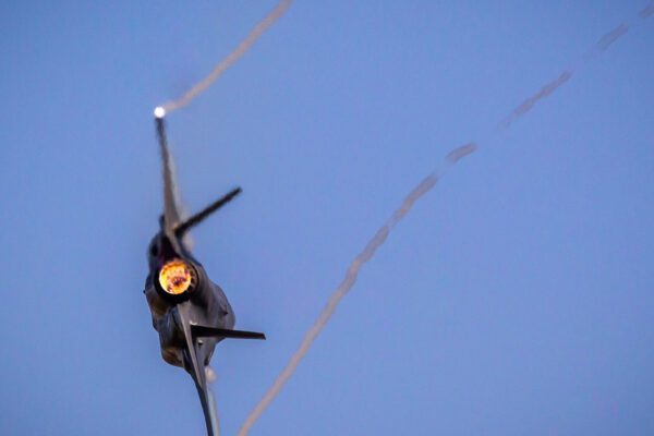
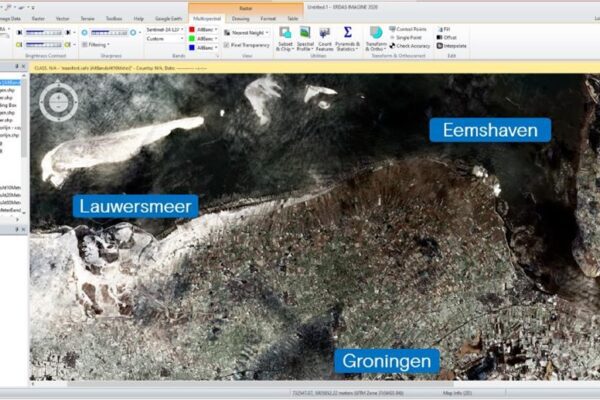
News

Filter options

Use the buttons to filter the list of results. The list is updated automatically.

Filter by solution
Filter by theme
Select a filter to narrow down the results. The page will refresh automatically.
Remote Sensing

Making Location Data Smarter with Machine Learning

April 30, 2021 – Whether you’re conducting an inspection using satellite imagery or simply watching videos on YouTube from your couch, machine learning is everywhere. Take Google, Facebook, or LinkedIn, for example, whose search functions are powered by various machine learning algorithms. The same goes for Netflix or Spotify,...

Remote Sensing

Ever Given: The real challenge is yet to come!

Apeldoorn, March 29, 2021 – The Ever Given, 400 meters long and 60 meters wide, is stuck across the Suez Canal. Getting it back on course is a challenge, but it will be done. Getting shipping traffic in the Suez Canal back up and running is an even bigger challenge! Blockage in the Suez Canal On average, there are...

Remote Sensing

Rijkswaterstaat is aiming higher

March 4, 2021 – Civil engineering structures (viaducts, portals, bridges, etc.) always deform slightly. This is taken into account in the design. However, regular monitoring is necessary to verify that the structure is behaving as intended in the design. Rijkswaterstaat (RWS) uses not only visual inspections but also deformation measurements for this purpose. Read more...

Remote Sensing

Snow-related disruptions in February

February 18, 2021 – Unfortunately (for some), the snow and ice have already melted away, but they did give us some fun on the ice and a few beautiful images. On February 11, it started snowing from the south, and the photos below capture a stunning scene. A wealth of data In early February, it started from the south...

From Data-Driven to Context-Aware at Make Geospatial Matter 2021

After nearly a year and a half, we were finally able to host our annual Make Geospatial Matter conference in person again. Whereas last year’s event was held entirely online, on Thursday, October 14, attendees were once again able to participate in person in various knowledge sessions, keynotes, and workshops, and network with one another in the Media Plaza at the Jaarbeurs Utrecht....

Remote Sensing

Preparing for the consequences of flooding

With an average of 847 mm of precipitation per year, the Netherlands is a wet country. Flooded streets and basements caused by heavy rainstorms are what make the Dutch climate so characteristic these days. And according to the Royal Netherlands Meteorological Institute (KNMI), annual precipitation will only increase due to climate change. Will it get even wetter? The Netherlands is the...

Remote Sensing

Mauritius, MV Wakashio: From Grounding to Salvage?

In the news reports, we see photos of the ship, oil leaking from it, and people cleaning up the oil, but where does all that oil end up? In the reports, we read and hear that about 1,000 tons of oil—that’s roughly 20 tanker trucks—has leaked. What does that mean? At a distance of ~9,500...

Remote Sensing

Beirut: The aftermath of the explosion

On the afternoon of August 4, 2020, a massive explosion occurred in the port of Beirut (Lebanon), resulting in countless casualties and severe damage to the infrastructure. Just one day later, we saw the first crystal-clear “aerial photos” appear in the news. The port area was completely destroyed, and in the harbor lay an overturned...

Digital Twin

Up-to-date, reliable, and high-quality data management

The basic and core records must be reliable and accessible to all relevant processes that support service delivery and operational management. That is why it is important that the data is “in order.” Data management must be up-to-date, reliable, and of high quality. This can be achieved with our data automation and change detection solution. Change detection is already a crucial...

Remote Sensing

The fireplace in the cloud

Government agencies rely on processes and input data to operate reliably and accurately. Most processes are continuously optimized to remain relevant, but they can still be labor-intensive—consuming time, resources, and money. With Schouw M.App, many of these processes at water authorities can be automated. Machine Learning in Waterways We work...

Aerial Photography Service
Remote Sensing

Agricultural registration via the Land Parcel Identification System

Fast aerial photography service for the Ministry of Economic Affairs and Climate Policy Agricultural policy in the European Union (EU) accounts for one of the largest financial allocations in the annual budget. This requires careful and accurate registration of all farmers eligible for subsidies, along with the correct compensation to which they are entitled. To...

IMAGEM the 2018 FD Gazellen Award

IMAGEM received the 2018 FD Gazelle Award. This year, *Het Financieele Dagblad* named 680 of the approximately 585,000 registered Dutch companies as 2018 Gazelles. Every year, the Financieele Dagblad organizes the FD Gazelle Awards to recognize the fastest-growing companies in the Netherlands. In its 15th year, the organizers have tightened their selection criteria...